


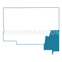
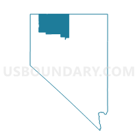
Voting District 9, Humboldt County, Nevada
About
Outline

Summary
| Unique Area Identifier | 615337 |
| Name | Voting District 9 |
| County | Humboldt County |
| State | Nevada |
| Area (square miles) | 1,224.00 |
| Land Area (square miles) | 1,217.89 |
| Water Area (square miles) | 6.12 |
| % of Land Area | 99.50 |
| % of Water Area | 0.50 |
| Latitude of the Internal Point | 40.95531820 |
| Longtitude of the Internal Point | -117.31685250 |
Maps

Graphs
Select a template below for downloading or customizing gragh for Voting District 9, Humboldt County, Nevada


Neighbors
Neighoring Voting District (by Name) Neighboring Voting District on the Map
- Voting District 12, Humboldt County, NV
- HUMBOLDT PRECINCT 14, Humboldt County, NV
- HUMBOLDT PRECINCT 15, Humboldt County, NV
- HUMBOLDT PRECINCT 7-2, Humboldt County, NV
- Precinct 28, Elko County, NV
- Precinct 6, Pershing County, NV
- Precinct 7, Pershing County, NV
- Precinct No. 2 - Argenta, Lander County, NV
- Precinct No. 5 - Argenta, Lander County, NV
Top 10 Neighboring County Subdivision (by Population) Neighboring County Subdivision on the Map
- Winnemucca CCD, Humboldt County, NV (13,532)
- Battle Mountain CCD, Lander County, NV (5,247)
- Imlay CCD, Pershing County, NV (1,914)
- Golconda CCD, Humboldt County, NV (1,579)
- Mountain City CCD, Elko County, NV (1,245)
Top 10 Neighboring Place (by Population) Neighboring Place on the Map
Top 10 Neighboring Unified School District (by Population) Neighboring Unified School District on the Map
- Elko County School District, NV (48,818)
- Humboldt County School District, NV (16,528)
- Pershing County School District, NV (6,753)
- Lander County School District, NV (5,775)
Top 10 Neighboring State Legislative District Lower Chamber (by Population) Neighboring State Legislative District Lower Chamber on the Map
- Assembly District 32, NV (80,177)
- Assembly District 33, NV (51,407)
- Assembly District 35, NV (51,108)
Top 10 Neighboring State Legislative District Upper Chamber (by Population) Neighboring State Legislative District Upper Chamber on the Map
Top 10 Neighboring 111th Congressional District (by Population) Neighboring 111th Congressional District on the Map
Top 10 Neighboring Census Tract (by Population) Neighboring Census Tract on the Map
- Census Tract 9601, Pershing County, NV (6,753)
- Census Tract 3, Lander County, NV (5,775)
- Census Tract 107.02, Humboldt County, NV (3,546)
- Census Tract 9517, Elko County, NV (2,669)
- Census Tract 106, Humboldt County, NV (2,278)